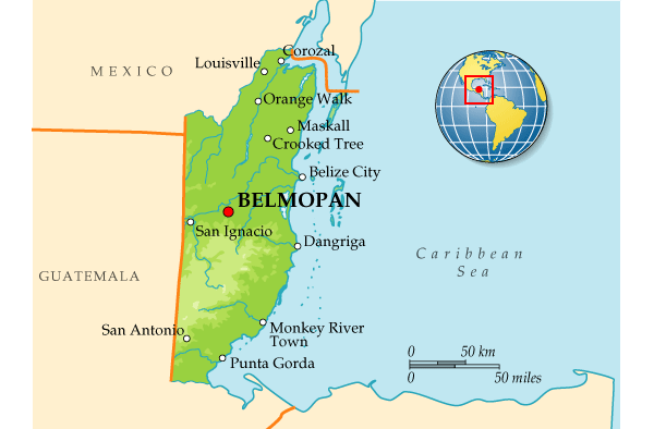
GEOGRAPHICAL LOCATION OF BELIZE
Belize is a Central American country situated on the eastern coast of the Yucatán Peninsula, bordered by both land and sea.
1. Absolute Location
- Latitude: Between 15°52’N and 18°30’N
- Longitude: Between 87°28’W and 89°15’W
2. Relative Location
- North: Bordered by Mexico (Quintana Roo State)
- South and West: Bordered by Guatemala
- East: Bordered by the Caribbean Sea
3. Region and Continent
- Continent: North America
- Region: Central America
- Subregion: Mesoamerica / Western Caribbean
4. Physical Features
| Feature | Description |
|---|
| Caribbean Coastline | ~386 km of coast along the Caribbean Sea |
| Belize Barrier Reef | Second-largest coral reef system in the world |
| Mountains | Maya Mountains (includes Victoria Peak – highest point) |
| Rivers | Belize River, Macal River, New River, Sibun River |
| Forests | Dense tropical rainforests, savannas, and mangroves |
| Islands & Cayes | Over 400 cayes and atolls, including Ambergris Caye and Caye Caulker |
5. Elevation
- Lowest Point: Sea level (Caribbean coast)
- Highest Point: Victoria Peak – 1,120 meters (3,675 ft) in the Maya Mountains
6. Climate Zones
- Tropical Climate
- Coastal Areas: Hot and humid
- Inland Areas: Warmer, sometimes cooler in the highlands
- Rainy Season: June to November
- Dry Season: February to May
7. Capital & Major Cities
| City | Note |
|---|
| Belmopan | Capital city (inland, central) |
| Belize City | Largest and most populous city; major port |
| San Ignacio | Inland town near Guatemala border |
| Orange Walk | Northern sugarcane region |
| Dangriga | Cultural hub of the Garifuna people |
8. Strategic Importance
- Located along the Caribbean coast, Belize serves as a gateway between Central America and the Caribbean.
- Its reef, forests, and rivers make it rich in natural resources and biodiversity.